Category

02_PRESS_COVERAGE

Large Area Hail Damage Mapping with dentCHECK

By 02_PRESS_COVERAGE, dentCHECK, Insights

What do the New Mexico desert, Elvis Presley’s 1962 Lockheed JetStar, and 8tree have in common?

In 2001, the Roswell International Air Center (RIAC) in New Mexico started to offer commercial aircraft parking. Up to 800 aircraft can be parked in a more than 5,000-acre fenced areas. American Airlines, United, Air Canada, and several others temporarily park their aircraft here. RIAC is also home to Evis Presley’s Lockheed Jetstar!

However, there is no roof over this giant open-air parking lot, which leaves the aircraft exposed to catastrophic weather events, such as hail storms.

One such extreme hail-event occurred last year. Numerous aircraft at RIAC were severely damaged. 8tree’s dentCHECK was called in to expedite damage-mapping of several wide-bodies.

Taking advantage of dentCHECK’s new large area panoramic mapping functionality (“panoLite”) it took just days to map and report each aircraft, compared to the weeks or months taken by traditional methods.

Large area damage mapping with panoLite.

How does it work?

To enable the powerful panoLite capability, specially-designed and reusable ‘smart-rulers’ (panoLite tapes) are applied to outline the hail-affected areas of interest.

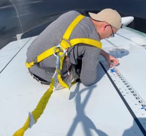
Applications Engineer Keith applying panoLite tapes on stabilizer.

The purpose of the panoLite smart-ruler is two-fold. First, the idea of the smart-ruler is a familiar one to aviation technicians, who currently follow an established workflow of applying masking tape marked with measurement increments to define an area of interest. Secondly, the smart-ruler is ‘smart’ and easy, as it only takes seconds to apply and peel off for re-use. Once applied, it delivers an incredibly efficient and seamless alternative to the traditional hail-mapping workflow, since it automatically communicates with the dentCHECK tool to create accurate large area damage-maps.

Once the panoLite smart-ruler has been applied, the familiar dentCHECK point-and-shoot dent mapping process can begin.

As long as some portion of the panoLite smart-ruler is visible to the dentCHECK tool during a given scan, then the well-known 8tree Damage Reporting Tool (DRT) automatically stitches the successive scans resulting in one large-area panoramic scan.

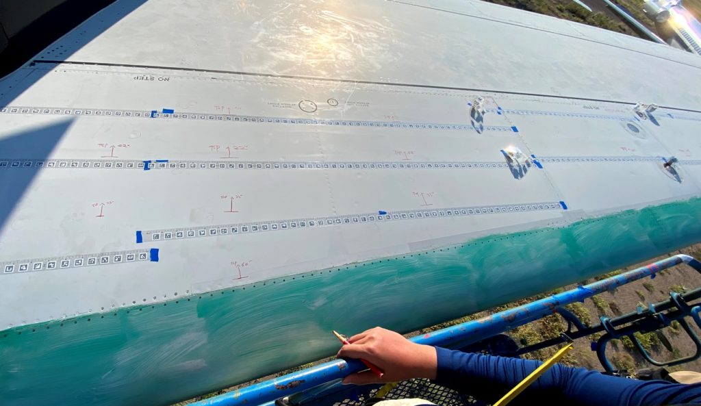
panoLite tapes applied on stabilizer to enable large area mapping of the whole area.

A comprehensive digital damage-report is generated as part of this automatic panoramic scan. The report format – familiar to most existing dentCHECK users – tabulates and itemizes each dent alongwith its key metrics, such as depth, size and inter-dent distance.

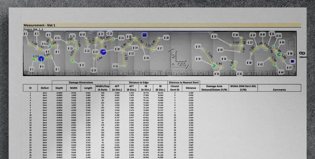
Part of an hail damage report (B777 – Slat).

End-to-end digitalized hail-damage reporting

The entire end-to-end digital process takes only a couple minutes, and equips operators and technicians with instantly-actionable damage-reports that guide informed repair strategies.

Does your organization still use slow, inaccurate and error-prone traditional manual methods to map catastrophic hail-damage?

If so, consider exploring the end-to-end digitalized dent-mapping workflow enabled by dentCHECK – a tool trusted by the leading airlines/MROs across the global aviation maintenance industry.

As for Elvis’ JetStar, after being parked for 35 years, it might not need hail damage-mapping anymore.


Contact us to receive the complete example report.

Towards dent measurement by drone

By 02_PRESS_COVERAGE, Automation, dentCHECK, Insights

« Can you make dentCHECK fly? »

This is a question which our customers and prospects ask on a regular basis. Dent damage is a chronic and recurring problem on aircraft, due to loading operations, hail-storms, bird strikes, etc.. But detecting, measuring and precisely locating such damage is a long and challenging process, which can be risky for inspectors working at height. As an example, on an annual basis, hail strikes affect 25% of the worldwide fleet and requires dozens of hours of inspection. How can the manual process of dent characterization be improved?

Aircraft hit by a hail strike, courtesy of ©The Aviation Herald http://avherald.com/h?article=47a10f14

In this context, a drone seems an obvious solution.

However, embedding dentCHECK on a drone is not an easy thing to do and requires intense development.

So, the question came up – Who can we collaborate with to make dentCHECK flying?

We identified Donecle as our launch partner to realize the vision of a flying dentCHECK. Donecle as the leader of automated aircraft visual inspection has a strong expertise in drone robotics, automation and aircraft maintenance processes.

After initial tests, we accelerated our collaboration under the approval of the DGA, working together with Dassault on Rafale inspections.

Working on next generation of automated drones for aircraft inspections

The solution features Donecle’s automated drone which will scan targeted areas where risks of dents are well known (such as doors, leading edge, HTP, tail…). The acquired 3D scan data will then be sent into our damage reporting tool which will automatically map and measure dents and generate an SRM-compliant report.

Typical use cases include inspection after hail strike or after hard contact during in-flight refueling for military aircraft; dent measurement around doors which are subject to impacts during loading and unloading operations; inspection of dents and depth defects during aircraft manufacturing, and any other dent inspection in areas difficult to access.

This new unique solution will enable much faster inspections, bring better accuracy thanks to the precise location of the dents relative to the aircraft structure, improve safety of workers (no need to climb on upper surfaces and dangerous areas) and contribute to a paperless process.

The question which is on everyone’s lips is of course: when will it be available? We are making good progress and after recent promising lab tests we conducted the first field-tests on aircraft, before larger deployment 2021.

So, stay tuned, we will soon officially announce the availability of this new product!

Learn more about Donecle: https://www.donecle.com/

Hail Damage Assessment on Aircrafts with panoLite™

By 02_PRESS_COVERAGE, dentCHECK, Insights

How do you handle hail damage inspection in your maintenance operations?

Hail damage is inevitable for a  busy fleet of aircraft.  It results in significant damage to the aircraft. Whether it’s safety critical or only cosmetic, the damage creates extensive maintenance work that requires precise assessment.

Are you still mapping hundreds of dents manually?

For most maintenance organizations, coping with hail damage situations is still a pain. Assessing all relevant data by hand is cumbersome and prone to error.

8tree’s new panoLite feature for dentCHECK® tackles this major challenge and might be the right tool for you.

panoLite enables large-area mapping. It allows the operator to cover a large hail damage scenario in just one dent-mapping job. Multiple individual dentCHECK scans are automatically stitched into an accurate panorama view, within seconds!

panoLite captures and analyzes up to a two-meter-wide area, at a time.  An SRM-compliant multi-dent report is seamlessly and instantly generated.

panoLite captures and analyzes damages on areas up to two meters wide, at a time. An SRM-compliant multi-dent report is seamlessly and instantly created.

How does it work?

The dentCHECK operator applies a reusable encoded panoLite tape onto the aircraft skin. While performing the scans, the operator needs to ensure, that each scan covers at least one coded marker on the panoLite tape.

The markers on the panoLite tape allow automatic and instant stitching of the scans without any user intervention.

Using the dentCHECK Damage Reporting Tool (DRT), operators can measure inter-dent distances across the whole panoramic area with a single a click.

Finally, the operator can export an end-to-end digital multi-dent report (.xls, .pdf) which shows a panorama view of the large area with all measurement results summarized in graphical and tabular views.

Read also this article from the 2019 Aerospace Maintenance Competition: Aircraft hail-damage: What tools will aircraft maintenance crews use for the job?

Aircraft hail-damage: What tools will aircraft maintenance crews use for the job?

By 02_PRESS_COVERAGE, Case Study, Insights

What does an aviation technician do when their aircraft is pummeled by hail?

To contrast traditional methods vs. emerging technology, more than 150 engineers, technicians, and students participated in a dent-mapping competition at the recent 2019 Aerospace Maintenance Competition. 80 teams were greeted by eight simulated dents on two airframe panels. Working under real-world time pressure and conditions, the teams had to accurately determine the ‘go/no-go’ status of the damage. Participants were tasked with mapping the dents using traditional methods, and then with 8tree’s purpose-built dentCHECK tool.

At every stage of the competition, dentCHECK surpassed participants’ expectations, while laying bare the inconsistencies associated with manual measurements. By the conclusion of the event, dentCHECK had become the dent-mapping tool-of-choice for participating teams.

But why? In the coming weeks, we will dive into the results of the world’s most comprehensive study of aviation dent-mapping.

Follow 8tree to see how dentCHECK helps operators efficiently map dents and make reliable decisions, instantly!